
The History of the Stephenson Highway Reserve in Churchlands
Updated: Jun 22
For many decades, the bushland and undeveloped land between Empire Avenue and Pearson Street in Churchlands has existed in a state of planning uncertainty.
While many locals simply know the area as the Churchlands Bushland, the land actually forms part of the much larger Stephenson Highway road reservation first proposed as part of Perth’s 1955 Stephenson-Hepburn Plan, the city’s first comprehensive metropolitan masterplan.

Over the decades, the scheme, the surrounding suburbs, and Perth’s broader planning priorities have evolved significantly. This article explores the history of the Stephenson Highway reservation, how it relates to Churchlands, and how a planning vision from the 1950s continues to shape discussions about the area today.
Key Point Summary • The Churchlands Bushland forms part of the historic Stephenson Highway reservation first proposed in 1955.
• No road has ever been constructed through this section of Churchlands.
• Much of the reserved land has gradually become informal urban bushland.
• The bushland has remained in planning limbo for decades despite major surrounding suburban development.
• As of June 2026, the Department of Planning, Lands and Heritage (DPLH) is overseeing an environmental study of the reserve before preparing a report for the WA Planning Commission.
• The WA Planning Commission will ultimately determine the future planning status of the land through a process that may include consultation with local governments, the Environmental Protection Authority and the wider community.
The Origins of the Stephenson-Hepburn Plan (1955)
By the early 1950s, Perth was experiencing rapid population growth and expanding suburban development following the end of World War II. Increasing car ownership and the spread of low-density suburbs were beginning to place pressure on the city’s existing road network, prompting concerns about how Perth would manage future growth.
In response, the Western Australian Government commissioned what became known as the Stephenson-Hepburn Plan, officially titled the Plan for the Metropolitan Region, Perth and Fremantle. Released in 1955, the plan was prepared by Professor Gordon Stephenson and planner J.A. Hepburn and became Perth’s first comprehensive metropolitan masterplan.

The plan proposed a long-term vision for Perth’s future expansion, including new residential areas, regional centres, public open space, and an extensive network of major roads and highways designed to accommodate increasing traffic volumes. At the time, this reflected modern international planning trends, particularly the growing emphasis on motor vehicle transport and large-scale suburban growth.
One of the key recommendations of the plan was the reservation of future transport corridors across Perth. These road reserves were intended to preserve land for major roads that planners believed may eventually be required as the metropolitan area expanded over coming decades.
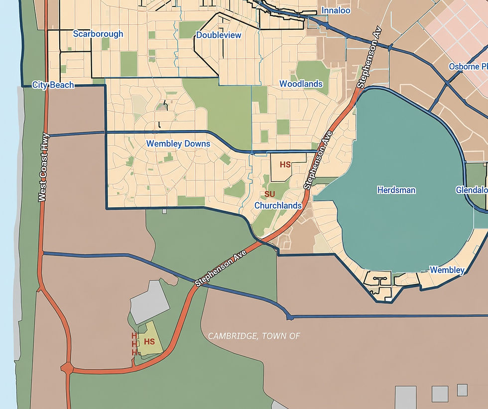
Among these proposed corridors was the Stephenson Highway reservation, parts of which extended through the Churchlands area. Historical maps from the period suggest that the corridor was once considered a significant component of Perth’s future transport network, although large sections were never ultimately developed as originally envisioned.
The Metropolitan Region Scheme (MRS)
Following the release of the Stephenson-Hepburn Plan in 1955, many of the proposed transport corridors were gradually incorporated into what became the Metropolitan Region Scheme (MRS) – the overarching planning framework used to guide land use and major infrastructure reservations across metropolitan Perth.
The MRS allowed land to be formally reserved for future public purposes, including regional roads, rail corridors, parks, and other strategic infrastructure. In practical terms, this meant certain areas of land were protected from development to preserve long-term planning options for future governments.

Importantly, reservation under the MRS did not necessarily mean that a road or project would definitely be built. In many cases, reservations were intended as long-term planning safeguards, sometimes remaining in place for decades while governments assessed future transport needs, funding priorities, and urban growth patterns.
Over time, some of the major road corridors proposed under the Stephenson-Hepburn Plan were ultimately constructed, while others were modified, reduced in scope, or never developed at all. As Perth evolved, planning priorities also changed – particularly regarding environmental protection, urban canopy, public open space, and the impact of major roads on established suburbs.
In Churchlands, portions of the original Stephenson Highway reservation remained largely undeveloped and gradually became informal bushland and open space. While the land continued to be associated with the regional road reserve planning framework, surrounding residential development expanded around it, creating the unusual situation that exists today – where a long-standing road reservation also functions as a valued local bushland corridor.

The Police Horse Stables Era (1953–1976)
Another lesser-known part of the area's history was the presence of the WA Police Horse Stables, which operated on land near Pearson Street from 1953 until 1976.
The site had an even longer association with mounted policing, with two police constables stationed there from 1946 after buildings were relocated from the former police horse facilities at Shenton Park.

Historical records and aerial imagery indicate that portions of the land associated with the Stephenson Highway reservation were used for police horse facilities, paddocks and related activities during this period.
Today, many local residents are unaware that the area once contained horse stables and grazing areas long before surrounding residential development expanded across Churchlands and Woodlands.
The timing of the police horse operations is significant because the Stephenson-Hepburn Plan was released in 1955, several years after the horse facilities had already been established. The planners responsible for identifying the future road reservation would therefore have been aware of the existing government use of the land.
Likewise, they would have known that the proposed corridor traversed other established land uses, including portions of Wembley Golf Course and areas of Bold Park.
The existence of the horse stables highlights an important aspect of the broader Stephenson Highway reservation. Although the corridor had been identified for possible future transport infrastructure, large sections remained undeveloped for decades and were often used for other government, recreational and community purposes in the meantime.
This reflects the long-term nature of Metropolitan Region Scheme reservations, where land may be protected for potential future infrastructure while simultaneously supporting a variety of interim uses. The continued use of the land for police horse operations for more than two decades after the release of the Stephenson-Hepburn Plan demonstrates that, even at that time, there was no immediate intention to construct the proposed road corridor.

Historical records indicate that the Police Horse Stables were ultimately relocated in 1976 due to the rapid suburban expansion occurring throughout Churchlands and neighbouring suburbs, together with the planned widening of Pearson Street.
There appears to be no evidence that the relocation was connected to any proposal to proceed with the Stephenson Highway reservation itself.
Instead, the closure of the horse facilities reflects the changing character of the area during the 1960s and 1970s, as formerly semi-rural land was progressively transformed into suburban residential communities. Despite the departure of the mounted police facilities, the Stephenson Highway reservation has remained largely untouched for many decades thereafter.

How the Stephenson-Hepburn Plan Shaped Modern Perth
Although some elements of the Stephenson-Hepburn Plan were never fully realised, the plan ultimately had a major influence on the growth and structure of modern Perth.
Many of the transport corridors and planning concepts proposed in the 1955 Stephenson-Hepburn Plan were progressively developed over the following decades and continue to shape how people move throughout Perth today.
Major roads and freeway systems influenced by the broader planning vision included:
Mitchell Freeway
Kwinana Freeway
Roe Highway
Reid Highway
Tonkin Highway
Stephenson Avenue (in part)
Other regional road corridors across metropolitan Perth
The plan also influenced the location of major suburban growth corridors, industrial areas, regional centres, and public open space networks across metropolitan Perth.
While some sections of the original Stephenson Highway vision were never ultimately constructed, other portions continue to influence Perth’s transport network today, including the ongoing Stephenson Avenue extension and associated roadworks in the Stirling and Osborne Park areas.

In some areas, previously reserved land was repurposed, modified, or partially retained as open space. In others - including parts of Churchlands - long-term road reservations remained in place despite surrounding suburbs becoming well-established residential communities.
This helps explain why the Churchlands Bushland debate is both a local issue and part of a much broader historical planning story that stretches back nearly 70 years.
The Modern Connector Road Debate
In recent years, discussion surrounding the Churchlands section of the Stephenson Highway reserve has increasingly focused on the possibility of constructing a local connector road between Empire Avenue and Dolomite Court.
Supporters of the proposal have generally argued that a connector road could help improve traffic flow and reduce “rat-running” through nearby residential streets, particularly within the Churchlands Green estate. For many years, residents have raised concerns about commuter traffic using roads such as University Avenue and Alumni Terrace as a shortcut between Empire Avenue and Pearson Street.

The issue became more prominent following investigations and discussions by the City of Stirling into possible future traffic and connectivity solutions for the area. In 2019, and again during later council discussions including 2024, the possibility of a local connector road through the reserve was formally considered.
However, the proposal has also generated significant community concern and opposition. Critics argue that constructing a road through the reserve would result in the loss of established bushland, reduce urban canopy, and negatively impact the environmental and visual character of the area.
Others have questioned whether a connector road remains necessary given changing traffic patterns, previous traffic reduction measures, and broader shifts in urban planning priorities. The City of Stirling has previously stated that traffic volumes through Churchlands Green reduced significantly following earlier traffic management measures at Pearson Street in 2021.
The City has also noted that traffic volumes along Cromarty Road remain well within the practical design capacity for a Local Distributor road, despite concerns that reducing through-traffic within Churchlands Green could redirect vehicles into surrounding streets.
Importantly, City of Stirling council documents from May 2024 also acknowledged that not proceeding with the connector road was an option due to the potentially high construction costs, low benefit-versus-cost ratio, and significant environmental impacts associated with the proposal.
The debate has ultimately highlighted a broader tension between historical transport planning and contemporary urban values. While the land was originally reserved for potential future road infrastructure, many local residents now increasingly view the bushland as an important environmental and community asset within an otherwise heavily developed urban area.
The Current Government Review Process
As of 2026, the future of the Churchlands section of the Stephenson Highway reserve remains uncertain, with multiple government agencies involved in different aspects of the land and planning process.
According to correspondence received from Main Roads WA and the Minister for Transport’s office in 2026, responsibility for the broader site is currently split between Main Roads WA, the Department of Planning, Lands and Heritage (DPLH), and Newman College.
In May 2026, Main Roads WA confirmed that it had completed a review of the surrounding road network and has provided advice to DPLH regarding the future of the reserve. In June 2026, the DPLH advised that an environmental study covering the Churchlands Bushland area would be undertaken prior to a report being prepared for the Western Australian Planning Commission. The findings of this study are anticipated to be received in early 2027, after surveys are completed during spring 2026.
At the same time, the City of Stirling has continued to discuss the future of the reserve through council motions and planning discussions.

Despite these developments, many local residents remain frustrated by the lack of a clear long-term outcome. After existing in planning limbo for decades, there is growing community sentiment that a definitive decision should now be made regarding the future of the land - whether that ultimately involves protection, reclassification, or alternative planning outcomes.
A Planning Legacy Still Waiting for Resolution
Nearly 70 years after the release of the Stephenson-Hepburn Plan, the Churchlands section of the Stephenson Highway reserve remains an unusual example of long-term metropolitan planning intersecting with a modern suburban community.
What was originally reserved as part of a major future regional road corridor in the 1950s never fully eventuated in this part of Perth. Instead, over time, the surrounding suburbs developed, schools expanded, traffic patterns evolved, and much of the land gradually became informal urban bushland valued by many local residents for its natural character and ecological importance.

At the same time, the reserve itself remained tied to overlapping government planning frameworks and responsibilities involving Main Roads WA, the Department of Planning, Lands and Heritage, the WA Planning Commission, local government, and portions of land associated with Newman College. The result has been decades of uncertainty surrounding the long-term future of the area.
For many residents, this has created a sense of planning limbo - where the land has remained reserved for a possible future purpose that has never clearly progressed, while also lacking the certainty, protection, and active management typically associated with recognised public bushland reserves.
This uncertainty has become increasingly visible in recent years. While sections of the bushland remain healthy and visually significant, other areas have experienced gradual deterioration, including informal tracks, littering, vegetation disturbance, and unmanaged access. Many locals now feel that regardless of the ultimate planning outcome, a clearer long-term direction is needed.

The debate also reflects broader changes in urban planning priorities since the 1950s. Modern planning increasingly places importance on urban canopy, biodiversity, environmental protection, walkability, and preserving green space within established suburbs.
In 2019, the City of Stirling released its Urban Forest Plan, which identified the importance of increasing and protecting urban tree canopy across the municipality.
This changing planning landscape may help explain more recent discussions surrounding the future protection of vegetation within the reserve and the City’s 2026 Notice of Motion relating to possible future Metropolitan Region Scheme amendments.
Ultimately, the future of the Churchlands Bushland remains unresolved. However, after decades of uncertainty, there appears to be growing community and government recognition that the area cannot simply remain in indefinite planning limbo forever.
Whether the final outcome involves formal protection, reclassification, partial development, or another planning solution entirely, the coming years may finally determine the long-term future of one of Churchlands’ most unusual and historically layered pieces of land.

References City of Stirling. (2019). Urban Forest Plan 2019–2030. City of Stirling, Western Australia.
City of Stirling. (2024). Minutes of the Ordinary Meeting of Council – 28 May 2024. City of Stirling, Western Australia.
City of Stirling. (2026). Minutes of the Ordinary Meeting of Council – 19 May 2026. City of Stirling, Western Australia.
City of Stirling Intramaps. (1974,2024). Historical aerial imagery and mapping data relating to the Stephenson Highway reserve and Churchlands Bushland area.
Main Roads Western Australia. (2025–2026). Correspondence and planning advice relating to the Stephenson Highway reserve and surrounding road network review.
Main Roads Western Australia. (2026). Stephenson Avenue Extension Project Materials and Mapping References.
Stephenson, G. & Hepburn, J.A. (1955). Plan for the Metropolitan Region, Perth and Fremantle. Government of Western Australia.
WA Police Historical Society Inc. (1950s–1970s). Historical records and imagery relating to the WA Police Horse Stables in Churchlands.
Western Australian Planning Commission. Metropolitan Region Scheme (MRS). Government of Western Australia.
Western Australian Government – Office of the Minister for Transport. (2026). Correspondence relating to the Stephenson Highway reserve review process.
Department of Planning, Lands and Heritage. (2025–2026). Planning framework references and correspondence relating to the Metropolitan Region Scheme and Stephenson Highway reserve.
Local community survey conducted in May 2026 regarding the proposed connector road, future development, and bushland preservation between Empire Avenue and Pearson Street, Churchlands (186 responses).
Environmental site observations and field photography conducted within the Churchlands Bushland area, May 2026.


Comments