
Churchlands Bushland: A Hidden Piece of Perth's History
- Editor
- Jun 15
- 7 min read
Updated: Jul 8
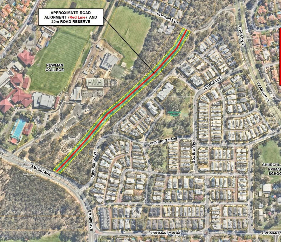
Churchlands Bushland is one of the most distinctive areas of urban bushland in Perth's western suburbs. Located within the suburb of Churchlands, the bushland occupies a corridor of remnant vegetation between Empire Avenue, Pearson Street, Dolomite Court, Newman College and the Churchlands Green estate.
While many local residents simply know it as the Churchlands Bushland, the area has a rich history connected to Perth's 1955 Stephenson-Hepburn Plan, the former WA Police Horse Stables, and a long-standing road reservation that has remained largely undeveloped for more than 70 years.

Today, the bushland is valued for its environmental significance, local history and role as an important green space within an increasingly urbanised part of Perth.
Location and access Churchlands Bushland is located between Empire Avenue, Pearson Street, Dolomite Court, Newman College and the Churchlands Green estate in Churchlands, Western Australia.
The bushland can be accessed from several informal entry points around its perimeter, including Coneflower Corner, Empire Avenue, Dolomite Court, Pearson Street and areas adjacent to Newman College. As a result, the area is well known to many local residents despite not being formally recognised as a public bushland reserve.

Although signage around parts of the reserve states that public access is restricted, the bushland remains easily accessible from multiple locations. Existing fencing is incomplete or deteriorated, and numerous informal walking tracks have developed throughout the site over many years.
These tracks vary from narrow bush trails to wider, well-defined pathways, reflecting regular use by local residents for walking, nature appreciation, birdwatching and informal recreation. The result is a bushland area that, while not formally managed as a public reserve, functions in many respects as a community-accessible natural space.
Despite being reserved for possible future road infrastructure for more than 70 years, no road has ever been constructed through this section of Churchlands. Instead, the land has gradually developed into a valued area of urban bushland, containing mature trees, native vegetation, informal walking tracks and habitat for local wildlife.

A unique pocket of urban bushland Churchlands Bushland sits within an increasingly urbanised part of Perth’s western suburbs. Surrounding areas have been progressively developed for housing, schools, roads, sporting grounds and other community uses, yet this corridor of land has remained largely undeveloped.
This has created an unusual situation. Although the land is still linked to a historical road reservation, much of it now functions as an informal bushland corridor and natural open space. The area contains mature trees, native understorey vegetation, zamia palms, informal tracks and sections of remnant bushland that provide a strong contrast to the surrounding suburban streets and built environment.
For many residents, the bushland provides a rare sense of nature within walking distance of home.

Environmental value The bushland contains vegetation typical of Perth’s Swan Coastal Plain environment, including mature Tuart, Marri, Jarrah, Peppermint, Paperbark and Zamia Palms.
While parts of the reserve have been disturbed over time through informal access, historical land uses and a lack of clear management, significant areas remain vegetated and continue to provide environmental value.
The bushland contributes to:
local tree canopy
urban cooling
habitat for birds and other wildlife
ecological connectivity
visual amenity
local biodiversity
opportunities for restoration and revegetation
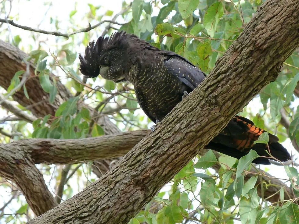
Birdlife observed within the area includes black cockatoos, galahs, magpies, ravens, Willie Wagtails, Singing Honeyeaters, Red Wattlebirds and birds of prey such as the Australian Hobby and Collared Sparrowhawk.
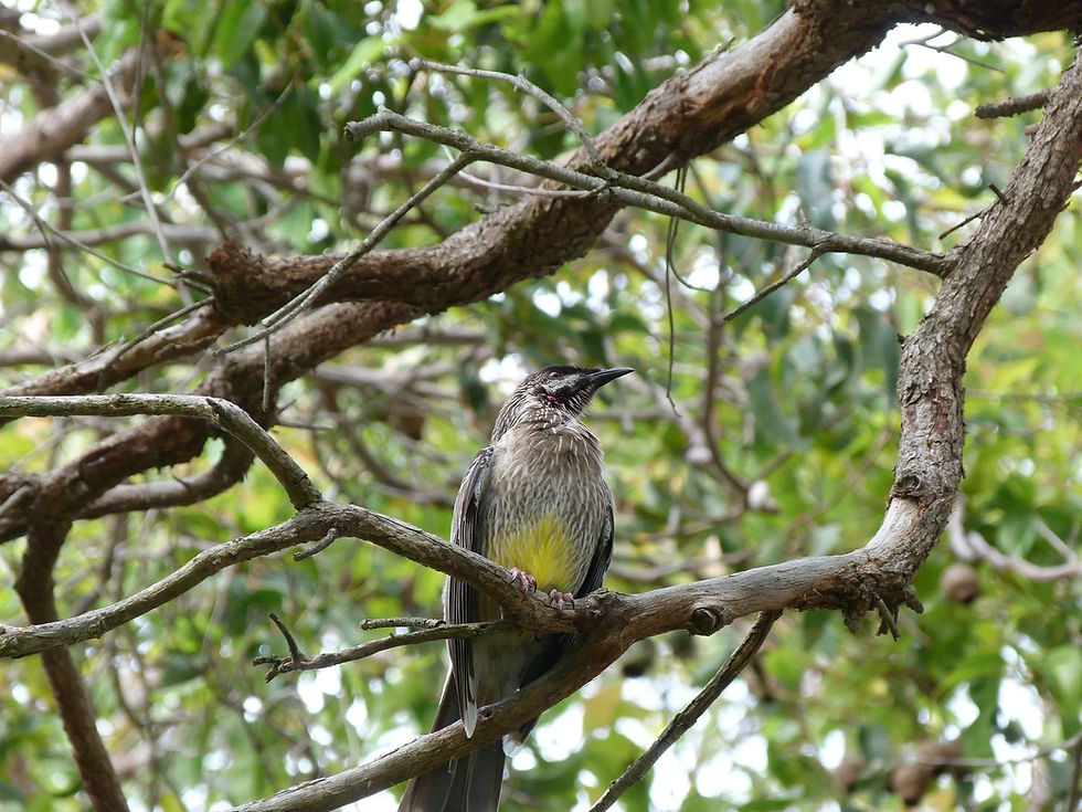
The presence of mature trees is particularly important, as large old trees provide shelter, foraging opportunities and habitat complexity that cannot be quickly replaced once lost. The bushland also forms part of a broader ecological linkage between major green spaces including Bold Park, Herdsman Lake and a network of smaller local reserves throughout Perth's western suburbs. Community bushland clean-up events have also been organised in recent years, reflecting growing local interest in the long-term care and management of the reserve.
The “Hero Tree”
One of the most significant environmental stories associated with Churchlands Bushland was the presence of a large old Jarrah tree estimated by renowned botanist Professor Kingsley Dixon to be approximately 450 years old.
The tree was described as a local “hero tree” due to its age, size and ecological importance, and was reported to support up to 80 species of wildlife.
Sadly, the tree died in 2025, but its presence highlighted the age and ecological significance of some of the vegetation within the reserve. Professor Dixon also noted mature Marri, Jarrah and Tuart trees within the bushland, along with ancient Zamia Palms estimated to be at least 250 years old.

The loss of the Hero Tree has reinforced community concern about the need for clearer protection and management of the remaining mature vegetation.
Historical significance
Churchlands Bushland is also historically significant because of its connection to the Stephenson-Hepburn Plan and the former WA Police Horse Stables.
The Stephenson-Hepburn Plan, released in 1955, was Perth’s first comprehensive metropolitan masterplan. It proposed a network of future roads, reserves and planning corridors to guide the city’s long-term growth. The land now known as Churchlands Bushland formed part of the proposed Stephenson Highway reservation.
Before and after the release of that plan, parts of the land near Pearson Street were also used by the WA Police Horse Stables. Records indicate that two police constables were stationed in the area from 1946, after buildings were relocated from Shenton Park. The horse stables operated on the site from 1953 until 1976.
Concrete remnants from the former stables can still be seen today within the Churchlands Bushland area, making them one of the few visible historical traces of the land’s earlier use.

Community value
For many locals, Churchlands Bushland is more than simply undeveloped land. It is a place for walking, exploring, birdwatching, informal recreation and connecting with nature.
Its location near Newman College, Churchlands Primary School, Churchlands Senior High School and surrounding residential areas gives it strong potential as an educational and community asset. Community interest in the bushland has grown significantly in recent years, particularly as residents have become more aware of its history, environmental value and uncertain planning status.
A key part of this growing community engagement has been the establishment of the Save Churchlands Bushland advocacy group, which was formed in June 2024. The group has worked to raise awareness of the bushland's environmental, historical and community significance through community engagement, media advocacy, public submissions, bushland clean-up events and discussions with local and State Government representatives.

Alongside broader community involvement, media coverage, and ongoing public discussion, these efforts have contributed to a growing recognition that the bushland deserves a clear long-term future and appropriate management.
The connector road debate
In recent years, the future of the bushland has been closely linked to debate about a possible local connector road between Empire Avenue and Pearson Street or Dolomite Court. Supporters of a connector road have argued that it could help improve traffic flow and reduce through-traffic in nearby residential streets.
Opponents have raised concerns about the loss of bushland, impacts on mature trees, environmental degradation, increased traffic, and the long-term consequences of building a road through one of the few remaining natural corridors in the area.
Importantly, more recent developments suggest that the proposed connector road may no longer be a preferred planning outcome. City of Stirling council motions and correspondence from State Government agencies have indicated that increasing attention is being given to the environmental value of the reserve and potential future Metropolitan Region Scheme amendments.
While no final decision has yet been made, it appears that the focus of the current planning process has shifted away from delivering a connector road and towards determining the long-term future management, protection and planning status of the land. As a result, the connector road proposal appears, at least for now, to be largely off the table while the broader review process continues.
Current planning status
As of 2026, the future of Churchlands Bushland still remains uncertain.
In early 2026, Main Roads WA completed a review of the surrounding road network and provided advice to the Department of Planning, Lands and Heritage. The Department has since advised that an environmental study will be undertaken for the area, including the Churchlands Bushland between Empire Avenue and Pearson Street. A report will then be presented to the Western Australian Planning Commission.
The findings of that environmental study are expected in early 2027, following field surveys planned for spring 2026.
If the WA Planning Commission proceeds with a Metropolitan Region Scheme amendment, the process is expected to involve further statutory steps, including:
Referral to the Environmental Protection Authority
Consultation with the City of Stirling and Town of Cambridge
Public consultation
The City of Stirling has also supported the need for an environmental report assessing the vegetation status and ecological quality of this part of the reserve before any future planning scheme amendment proceeds.
Why the bushland matters
Churchlands Bushland matters because it represents a rare combination of environmental, historical and community values. It is:
a remnant area of urban bushland
part of a major historical road reservation
connected to Perth’s 1955 metropolitan planning history
associated with the former WA Police Horse Stables
habitat for native birds and wildlife
home to mature trees and ancient Zamia Palms
valued by local residents
strategically located between larger green spaces such as Bold Park and Herdsman Lake
After more than 70 years of planning uncertainty, many residents believe the time has come for a clear decision about the future of the land.
Looking ahead
The future of Churchlands Bushland will ultimately depend on decisions made by State Government agencies, the Western Australian Planning Commission, local government and the wider community.
Whatever the final planning outcome, the bushland’s environmental and historical values are now better understood than they have been for many years.
For local residents, the hope is that this long-standing area of uncertainty can finally be resolved in a way that protects the bushland, recognises its history, and ensures it is properly managed for future generations.


Comments